Context of the project
The overall objective of the LATAWAMA intervention is to promote an equitable use, a benefit sharing and a common risk mitigation in the prevention of transboundary water pollution of Lake Tanganyika and its basin. The project supports the Lake Tanganyika Authority (LTA), an inter-regional structure with a mandate and missions to promote the protection and the sound management of the water resources of the Lake and its basin.
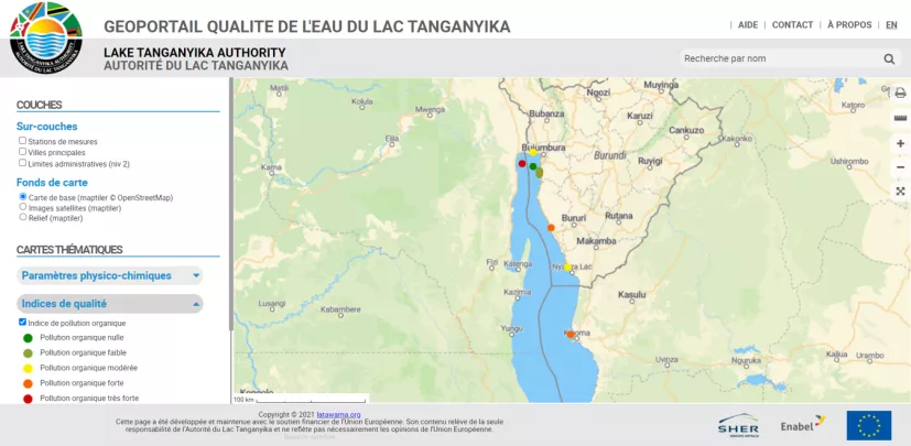
Within the framework of the Lake Tanganyika Water Management (LATAWAMA) project, this technical support mission consists of setting up a WebGIS application, making data on the water quality of Lake Tanganyika available to the partners, institutions and the general public.,
The implementation of this solution requires the following activities in three phases:
Phase 1 – Study
- Identification of the stakeholders involved in WebGIS (users, suppliers of the data required)
- Determination of the desired uses, the expected results in order to define the WebGIS objectives
- Definition of the data required to achieve the WebGIS objectives
- Analysis of existing data to identify the availability and the geographical accuracy
- Establishing strategies for acquiring existing data •
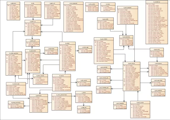
- Formal definition of the data structure to be used by the information system (Conceptual Data Model)
- Definition of the list of functionalities required to meet the WebGIS objectives
- Comparative analysis of the different GIS solutions that can be used to achieve the defined objectives
- Choice of the graphic charter
- Design of a WebGIS prototype or mock-up
Phase 2 – Development
- Development and production of a tool for capturing physico-chemical measurements intended for laboratories
- Implementation of procedures for collecting, processing and sharing data on the water quality of Lake Tanganyika
- Setting up the WebGIS technical infrastructure in a test environment
- Development and enrichment of the database
- Development of a client application (functionalities and business tools)
Phase 3 – Implementation
- Deployment of the WebGIS from the test environment to a production server hosted by a chosen hosting provider
- Training for use and administration
Project images